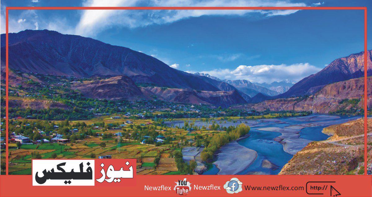
Kaghan Valley
Kaghan valley is considered to be a jewel among the attractive valleys of the Mansehra district in Pakistan. The valley is approximately 160 kilometers long and is a popular summer hotel for tourists from both within the country and abroad.
Salient features:
Following are the salient features of Kaghan valley:
- Kunhar river – the main feature of the valley
- Gujar nomads with their cattle
- Honey sellers
- Potato farms
- Trout fish
The popular languages spoken in the valley are Hindko and Gojri while the national language Urdu is additionally widely understood. Kaghan valley is situated at an approximate distance of 250 kilometers from the capital, Islamabad. The road that leads to the valley passes through different towns and cities, notably Taxila, Abbottabad, Mansehra, and Balakot. The last city/town that comes before the beginning of Kaghan valley is Balakot.
Balakot was the place of a crucial historical battle between the Sikhs and Muslims within the early 19th century and is additionally home to the grave of Syed Ahmed Shaheed, a vital Muslim leader. Tourists coming from distant areas usually choose to reside in Balakot for the night before officially venturing into the scenic valleys of Kaghan.
Kawai
After stepping into Kaghan, the first town that comes our way is Kawai. Kawai is situated at a distance of 24 kilometers (15 miles) from Balakot and is home to a little number of individuals. The track that passes through Kawai winds through thick forests of pine and might be extremely liable to landslides in wet weather.
Shogran
After crossing Kawai, visitors find themselves in Shogran, a heavenly place with beautiful views. Shogran is situated at an altitude of 2400 (7500 feet) meters above sea level. At this altitude, it stands well above the valley. Shogran includes a number of guest houses that will be used as an abode for the night. Most well-known is the forestry department rest and guest house.
Shogran offers magnificent views of a few beautiful snowcapped peaks, namely:
- Musa ka Musalla
- Makra
- Malika Parbat
Siri Paye
Once you cross Shogran, a steep climb leads you to the stunning plateau of Siri and Paya. Siri and Paya is a plateau right above the scenic Shogran. Paya is instantly recognized for its beautiful lake that reflects the greenery around it. Further ahead, at Siri, the plateau is situated. Siri Paye is reached through a jeep drive or a 2.5-hour hike from Shogran.
Paya is situated at a height of 11,200 feet or3414 meters. The space between Siri and Paya is bridged in a quarter-hour via jeep. there’s a forest building situated at Siri.
Manna Meadows
Manna Meadows is situated at an altitude of 8000 feet above sea level. It takes approximately 4 hours from Paya to achieve Manna meadows via a hike. The best time to go to Manna Meadows is July/August because it’s now the year when the flowers are fully bloomed. There’s also a 3hour hiking track from Manna Meadows to Shogran.
Sharan
A 16-kilometer jeep track from Paras which is situated on the other bank of river Kunhar leads to Sharan. Sharan is situated at an altitude of 7872 feet.
It is part of the mountain range which boasts Musa ka Musalla as its highest peak at 13,372 feet.
Shinu
Another town in the vicinity of Sharan worth mentioning is Shinu. The town is well-known for its Trout hatchery which could be a rich source of trout fish. Tourists should purchase a permit at Shinu which allows them to fish in the well-stocked river.
Jared
Jared is a settlement known for its handicrafts. The handicraft business is run both privately and together with the govt. the govt. also runs a handicraft development center at Jared. The handicrafts sold at Jared mainly comprise:
- Carved furniture
- Handmade woolen shawls
Khanian
At a little distance from Mahanderi, comes Khanian. Khanian is situated at the right bank of river Kunhar and is a base camp for people venturing into the Kamal Ban forest and Danna Meadows.
Danna Meadows
A ten-kilometer jeep track from Khanian results in Danna Meadows. Despite the track being only 10 km long it still takes about an hour. Danna Meadows is situated at an altitude of 10,000 feet and presents views of a variety of snowcapped peaks that are well above 15,000 feet.
However, the jeep track is currently inaccessible which requires around three hours on foot to succeed in Danna Meadows.
Malkandi Forest
Malkandi forest is a densely populated forest abundant with black bears and leopards. It also serves as home to a small number of cattle farmers. Black bears often venture into areas of human population and damage crops, therefore shooting down a bear is thought to be a big thing in Malkandi. Shooters are often rewarded by forest officers.
Apart from black bears and leopards, a small number of red bears, musk deer, and Ibex’s can be found in Malkandi forest.
Naran
Naran is the most visited and densely populated tourist attraction in the valley. It is home to a number of hotels, restaurants, and tent villages. Naran is situated at an altitude of 2427 meters or 7693 feet above sea level. The approximate distance from Balakot is 82 kilometers (51 miles).
Naran is the center of tourism in the Kaghan valley yet there is no bank in Naran.
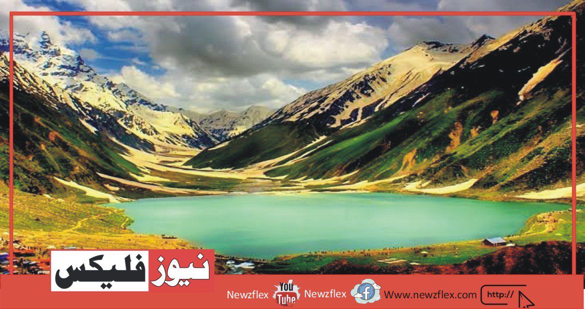
Lake Saif-ul-Muluk
10 kilometers east of Naran is Lake Saif-ul-Muluk. It is situated at an altitude of around 3,212 meters or 10,537 feet above sea level. In winter, the lake is covered by a sheet of ice, while in April, when the ice begins to melt; miniature icebergs can be seen floating on the surface of the lake. The mountain right behind the lake is called Malika Parbat.
From the lake, one can trek up to the Saif-ul-Muluk glacier which is located southwards. One can also trek over a 4300-meter pass and reach the settlements on the other side of the lake.
Aansoo Lake
Aansoo Lake is situated near Malika Parbat in the Himalayan mountain range. The word Aansoo in Urdu stands for ‘teardrop’. The lake has been named so because of its tear-like shape. Aansoo Lake has been said to be discovered by Pakistan Air Force Pilots in 1993 while flying at a relatively low altitude. Before this, the lake was unknown even to the locals.
Aansoo Lake can be reached via a strenuous trek from Lake Saif-ul-Muluk. However, there is an alternate route to reach the lake from Mahanderi but this route is not preferred as it is a less trodden route and the difficulties are unknown. The best season to visit Aansoo Lake is from May to July.
Batakundi
Moving towards the Babusar pass, the first town that one stumbles across is Batakundi. The altitude of Batakundi is 2,624 meters or 8607 feet above sea level. It is situated at a distance of 16 kilometers from Naran. A PWD rest house and three other hotels are situated at Batakundi. Batakundi is the last village in the valley to stay open all winter.
Lalazar
A jeep track about two kilometers from Batakundi leads to Lalazar. Lalazar is famous for its meadows full of blooming flowers during the spring season. There are also numerous potato fields situated in Lalazar.
Burawai
Burawai is situated at a distance of around 13 kilometers from Batakundi. The road from Naran to Jalkhad also known as the Manshera-Naran-Jalkhad highway is one of the best roads in the country.
Jalkhad
Further up the road is Jalkhad. It is at a distance of 12 km from Burawai. This is the place where the Jalkhad stream flows into the mighty river Kunhar. From Jalkhad, the MNJ highway bifurcates.
- One part leads to Chilas and joins KKH.
- Whereas the other goes to Sharda and ultimately reaches Muzafarrabad in Azad Kashmir.
Pyala Lake
Pyala Lake is situated about 1 kilometer east of Jalkhad. The water of this lake is of a bluish hue. Pyala stands for ‘bowl’ in Urdu. The lake has been named so due to its bowl-like shape.
Noori Top/ Noori Lake
Noori Top is situated at an altitude of 12900 feet above sea level. It remains snowcapped throughout the year. From Noori’s top two hiking tracks to Ratti Gali and Saral Lake originate.
Noori Lake lies at the border of Kaghan Valley and Azad Kashmir. It is at an altitude of 12,780 feet above sea level. The lake can be reached by a Jeep via Jalkhad in 1.5 hours.
Besal
The road north of Jalkhad steeply rises and reaches Besal, a wilderness with treacherous terrain. In stark contrast with the lush green forests of the Kaghan Valley, Besal offers mere views of jagged rocks.
It also serves as a base camp for Lulusar Lake.
Lulusar Lake
The lake is situated at an altitude of 10,000 feet. The water flowing out of the lake flows into the river Kunhar further contributing to its strength. Lulusar Lake is wreathed in blue and gold wildflowers.
Dudipatsar Lake
Dudipatsar is another beautiful lake encircled by snow-clad peaks. It is at a height of 3800 meters. The word “dudi” means white and “sar” means lake. This name has been given to the lake because of the white color of snow at the surrounding peaks.
Dudipatsar Lake is one of the hardest places to reach in the valley. A tough trek of around 6 hours from Besal leads to the lake.
Babusar Pass
The Kaghan Valley is blocked at the end by high mountains but a pass lets the jeep-able road snake over into the Chilas Valley. This is the 4,173 meters high Babusar Pass. Babusar pass is the end of the Kaghan valley which commands the whole Kaghan panorama. Babusar Pass is 161 km from Balakot and 75 km from Naran. A minaret here points to the highest point of the pass as 13,690 ft.
Babusar pass is the gate between Kaghan and Gilgit valley. Road at Babusar Pass is remained closed from October to June, also restricted during monsoon season.
وادی کاغان
وادی کاغان کو پاکستان کے ضلع مانسہرہ کی خوبصورت وادیوں میں سے ایک زیور سمجھا جاتا ہے۔ یہ وادی تقریباً 160 کلومیٹر لمبی ہے اور ملک اور بیرون ملک سے آنے والے سیاحوں کے لیے موسم گرما کی چھٹیوں کا ایک مشہور مقام ہے۔
نمایاں خصوصیات
وادی کاغان کی نمایاں خصوصیات درج ذیل ہیں۔
نمبر1:دریائے کنہار – وادی کی اہم خصوصیت
نمبر2:گجر خانہ بدوش اپنے مویشیوں کے ساتھ
نمبر3:شہد بیچنے والے
نمبر4:آلو کے فارمز
نمبر5:ٹراؤٹ مچھلی
وادی میں بولی جانے والی مقبول زبانیں ہندکو اور گوجری ہیں جبکہ قومی زبان اردو بھی بڑے پیمانے پر سمجھی جاتی ہے۔ وادی کاغان دارالحکومت اسلام آباد سے تقریباً 250 کلومیٹر کے فاصلے پر واقع ہے۔ وادی کی طرف جانے والی سڑک مختلف قصبوں اور شہروں سے گزرتی ہے، خاص طور پر ٹیکسلا، ایبٹ آباد، مانسہرہ اور بالاکوٹ۔ آخری شہر/قصبہ جو وادی کاغان شروع ہونے سے پہلے آتا ہے وہ بالاکوٹ ہے۔
بالاکوٹ 19ویں صدی کے اوائل میں سکھوں اور مسلمانوں کے درمیان ایک اہم تاریخی لڑائی کا مقام تھا اور یہاں ایک اہم مسلم رہنما سید احمد شہید کی قبر بھی ہے۔ دور دراز کے علاقوں سے آنے والے سیاح عموماً کاغان کی خوبصورت وادیوں میں سرکاری طور پر جانے سے پہلے رات کے لیے بالاکوٹ میں ٹھہرنے کو ترجیح دیتے ہیں۔
کاوائی
کاغان میں داخل ہونے کے بعد پہلا قصبہ جو ہمارے راستے میں آتا ہے وہ کاوائی ہے۔ کاوائی بالاکوٹ سے 24 کلومیٹر (15 میل) کے فاصلے پر واقع ہے اور یہاں بہت کم لوگوں کا گھر ہے۔ وہ ٹریک جو دیودار کے گھنے جنگلات سے کاوائی ہواؤں سے گزرتا ہے اور گیلے موسم میں لینڈ سلائیڈنگ کا انتہائی خطرہ ہو سکتا ہے۔
شوگران
کاوائی کو عبور کرنے کے بعد، زائرین خود کو شوگران میں پاتے ہیں، جو خوبصورت نظاروں کے ساتھ ایک آسمانی جگہ ہے۔ شوگران سطح سمندر سے 2400 (7500 فٹ) میٹر کی بلندی پر واقع ہے۔ اس بلندی پر یہ وادی سے بالکل اوپر کھڑا ہے۔ شوگران میں کئی گیسٹ ہاؤسز ہیں جنہیں رات کے لیے ٹھکانے کے طور پر استعمال کیا جا سکتا ہے۔ سب سے زیادہ معروف محکمہ جنگلات کا ریسٹ اور گیسٹ ہاؤس ہے۔
شوگران تین خوبصورت برف پوش چوٹیوں کے شاندار نظارے پیش کرتا ہے، یعنی
نمبر1:موسیٰ کا مصلہ
نمبر2:مکرہ
نمبر3:ملیکہ پربت
سری پائے
ایک بار جب آپ شوگران کو عبور کرتے ہیں تو، ایک کھڑی چڑھائی آپ کو سری اور پائی کے شاندار سطح مرتفع کی طرف لے جاتی ہے۔ سیری اور پایا خوبصورت شوگران کے بالکل اوپر ایک سطح مرتفع ہے۔ پیا کو فوری طور پر اس کی خوبصورت جھیل کے لیے پہچانا جاتا ہے جو اس کے آس پاس کی ہریالی کی عکاسی کرتی ہے۔ مزید آگے، سری پر سطح مرتفع واقع ہے۔ سری پائے تک جیپ ڈرائیو یا شوگران سے 2.5 گھنٹے کی پیدل سفر کے ذریعے پہنچا جا سکتا ہے۔
پایا 11,200 فٹ یا 3414 میٹر کی بلندی پر واقع ہے۔ سری اور پائی کے درمیان فاصلہ جیپ کے ذریعے 15 منٹ میں طے کیا جا سکتا ہے۔ سری میں ایک فارسٹ ریسٹ ہاؤس واقع ہے۔
منا میڈوز
منا میڈوز سطح سمندر سے 8000 فٹ کی بلندی پر واقع ہے۔ پیا سے پیدل سفر کے ذریعے منا میڈوز تک پہنچنے میں تقریباً 4 گھنٹے لگتے ہیں۔ منا میڈوز کا دورہ کرنے کا بہترین وقت جولائی/اگست ہے کیونکہ یہ سال کا یہ وقت ہوتا ہے جب پھول پوری طرح کھلتے ہیں۔ منا میڈوز سے شوگران تک 3 گھنٹے کا ہائیکنگ ٹریک بھی ہے۔
شرن
پارس سے 16 کلومیٹر کا جیپ ٹریک جو دریائے کنہار کے مخالف کنارے پر واقع ہے، شرن کی طرف جاتا ہے۔ شرن 7872 فٹ کی بلندی پر واقع ہے۔یہ ایک حصہ ہے اگر پہاڑی سلسلہ جو موسیٰ کا مسلہ کو 13,372 فٹ کی بلند ترین چوٹی کے طور پر فخر کرتا ہے۔
شنو
شرن کے قرب و جوار میں ایک اور قصبہ قابل ذکر ہے شنو۔ یہ قصبہ اپنی ٹراؤٹ ہیچری کے لیے مشہور ہے جو ٹراؤٹ مچھلیوں کا ایک بھرپور ذریعہ ہے۔ سیاح شنو میں ماہی گیری کا لائسنس خرید سکتے ہیں جو انہیں اچھی طرح سے ذخیرہ شدہ دریا میں مچھلیاں پکڑنے کی اجازت دیتا ہے۔
جیرڈ
جیرڈ ایک چھوٹا سا شہر ہے جو اپنی دستکاری کے لیے جانا جاتا ہے۔ دستکاری کا کاروبار نجی طور پر اور حکومت کے تعاون سے چلایا جاتا ہے۔ حکومت جیرڈ میں دستکاری کی ترقی کا ایک مرکز بھی چلاتی ہے۔ جیرڈ میں فروخت ہونے والی دستکاری بنیادی طور پر پر مشتمل ہے
نمر1:کھدی ہوئی فرنیچر
نمبر2:ہاتھ سے بنی اونی شالیں۔
خانیان
مہندیری سے تھوڑے فاصلے پر خانیاں آتا ہے۔ خانیان دریائے کنہار کے دائیں کنارے پر واقع ہے اور کمال بان جنگل اور ڈنا میڈوز میں جانے والے لوگوں کے لیے ایک بیس کیمپ کے طور پر کام کرتا ہے۔
ڈنا میڈوز
خانیاں سے دس کلومیٹر کا جیپ ٹریک ڈنا میڈوز کی طرف جاتا ہے۔ ٹریک صرف 10 کلومیٹر لمبا ہونے کے باوجود ایک گھنٹہ لگتا ہے۔ ڈنا میڈوز 10,000 فٹ کی بلندی پر واقع ہے اور کئی برف پوش چوٹیوں کے نظارے پیش کرتا ہے جو 15,000 فٹ سے اوپر ہیں۔
تاہم، جیپ ٹریک فی الحال ناقابل رسائی ہے جسے ڈنا میڈوز تک پہنچنے کے لیے تقریباً تین گھنٹے پیدل چلنا پڑتا ہے۔
ملکنڈی جنگل
ملکنڈی کا جنگل ایک گنجان آباد جنگل ہے جس میں کالے ریچھ اور چیتے پائے جاتے ہیں۔ یہ مویشی کسانوں کی ایک چھوٹی سی تعداد کے گھر کے طور پر بھی کام کرتا ہے۔ کالے ریچھ اکثر انسانی آبادی کے علاقوں میں گھس جاتے ہیں اور فصلوں کو نقصان پہنچاتے ہیں، اس لیے ملکانڈی میں ریچھ کو مار گرانا ایک بڑی بات سمجھا جاتا ہے۔ نشانہ بازوں کو اکثر جنگلات کے افسران انعام دیتے ہیں۔
کالے ریچھ اور چیتے کے علاوہ، مالکنڈی کے جنگل میں سرخ ریچھ، کستوری ہرن اور آئیبیکس کی ایک چھوٹی سی تعداد پائی جاتی ہے۔
ناران
ناران وادی کا سب سے زیادہ دیکھنے والا اور گنجان آباد سیاحوں کی توجہ کا مرکز ہے۔ یہ متعدد ہوٹلوں، ریستوراں اور خیمہ گاؤں کا گھر ہے۔ ناران سطح سمندر سے 2427 میٹر یا 7693 فٹ کی بلندی پر واقع ہے۔ بالاکوٹ سے تقریباً فاصلہ 82 کلومیٹر (51 میل) ہے۔
ناران وادی کاغان میں سیاحت کا مرکز ہے اس کے باوجود ناران میں کوئی بینک نہیں ہے۔
جھیل سیف الملوک
ناران سے 10 کلومیٹر مشرق میں جھیل سیف الملوک ہے۔ یہ سطح سمندر سے تقریباً 3,212 میٹر یا 10,537 فٹ کی بلندی پر واقع ہے۔ سردیوں میں، جھیل برف کی چادر سے ڈھکی ہوتی ہے، جب کہ اپریل میں، جب برف پگھلنا شروع ہو جاتی ہے۔ جھیل کی سطح پر چھوٹے آئس برگ تیرتے ہوئے دیکھے جا سکتے ہیں۔ جھیل کے بالکل پیچھے پہاڑ کو ملکہ پربت کہتے ہیں۔
جھیل سے سیف الملوک گلیشیر تک جا سکتے ہیں جو جنوب کی طرف واقع ہے۔ ایک بار 4300 میٹر کے پاس سے بھی ٹریک کر سکتے ہیں اور جھیل کے دوسری طرف کی بستیوں تک پہنچ سکتے ہیں۔
آنسو جھیل
آنسو جھیل ہمالیہ کے پہاڑی سلسلے میں ملیکا پربت کے قریب واقع ہے۔ اردو میں آنسو کا لفظ ’آنسو‘ ہے۔ اس جھیل کا نام اس کی آنسو نما شکل کی وجہ سے رکھا گیا ہے۔ آنسو جھیل کو پاکستان ایئر فورس کے پائلٹس نے 1993 میں نسبتاً کم اونچائی پر پرواز کرتے ہوئے دریافت کیا تھا۔ اس سے پہلے یہ جھیل مقامی لوگوں کے لیے بھی نامعلوم تھی۔
جھیل سیف الملوک سے ایک سخت سفر کے ذریعے آنسو جھیل تک پہنچا جا سکتا ہے۔ تاہم مہندیری سے جھیل تک پہنچنے کے لیے ایک متبادل راستہ موجود ہے لیکن اس راستے کو ترجیح نہیں دی جاتی ہے کیونکہ یہ ایک کم پیدل راستہ ہے اور مشکلات کا علم نہیں ہے۔ آنسو جھیل کا دورہ کرنے کا بہترین موسم مئی سے جولائی تک ہے۔
بٹاکنڈی
بابوسر درہ کی طرف بڑھتے ہوئے، پہلا قصبہ جس سے کوئی ٹھوکر کھاتا ہے وہ بٹاکنڈی ہے۔ بٹاکنڈی کی بلندی سطح سمندر سے 2,624 میٹر یا 8607 فٹ ہے۔ یہ ناران سے 16 کلومیٹر کے فاصلے پر واقع ہے۔ ایک پی ڈبلیو ڈی ریسٹ ہاؤس اور تین دیگر ہوٹل بٹاکنڈی میں واقع ہیں۔ بٹاکنڈی وادی کا آخری گاؤں ہے جو تمام موسم سرما میں کھلا رہتا ہے۔
لالہزار
بٹاکنڈی سے تقریباً دو کلومیٹر کا ایک جیپ ٹریک لالہ زار کی طرف جاتا ہے۔ لالہ زار موسم بہار کے موسم میں کھلتے پھولوں سے بھرے اپنے میدانوں کے لیے مشہور ہے۔ لالہ زار میں آلو کے بے شمار کھیت بھی واقع ہیں۔
بروائی
بوروائی بٹاکنڈی سے تقریباً 13 کلومیٹر کے فاصلے پر واقع ہے۔ ناران سے جلکھڈ تک کی سڑک جسے مانسہرہ-ناران-جلکھڈ ہائی وے بھی کہا جاتا ہے ملک کی بہترین سڑکوں میں سے ایک ہے۔
جلکھد
آگے سڑک جلکھڈ ہے۔ یہ بوروائی سے 12 کلومیٹر کے فاصلے پر ہے۔ یہ وہ جگہ ہے جہاں سے جلکھڈ ندی طاقتور ندی کنہار میں بہتی ہے۔ جلکھڈ سے، ایم این جے ہائی وے دو حصوں میں بٹ جاتی ہے۔
نمبر1:ایک حصہ چلاس کی طرف جاتا ہے اور کے کے ایچ میں شامل ہوتا ہے۔
نمبر2:جبکہ دوسرا شاردہ جاتا ہے اور بالآخر آزاد کشمیر کے مظفرآباد پہنچ جاتا ہے۔
پیالہ جھیل
پیالہ جھیل جلکھڈ سے تقریباً 1 کلومیٹر مشرق میں واقع ہے۔ اس جھیل کا پانی نیلے رنگ کا ہے۔ پیالہ اردو میں ‘کٹورا’ کا مخفف ہے۔ اس جھیل کا نام پیالے جیسی شکل کی وجہ سے رکھا گیا ہے۔
نوری ٹاپ/ نوری جھیل
نوری ٹاپ سطح سمندر سے 12900 فٹ کی بلندی پر واقع ہے۔ یہ سال بھر برف سے ڈھکی رہتی ہے۔ نوری سے لے کر رتی گلی اور سرل جھیل تک دو ہائیکنگ ٹریکس نکلتے ہیں۔ نوری جھیل وادی کاغان اور آزاد کشمیر کی سرحد پر واقع ہے۔ یہ سطح سمندر سے 12,780 فٹ کی بلندی پر ہے۔ جھیل تک ایک جیپ کے ذریعے جلکھڈ کے ذریعے 1.5 گھنٹے میں پہنچا جا سکتا ہے۔
بیسل
جلکھڈ کے شمال کی سڑک بہت تیزی سے اٹھتی ہے اور بیسال تک پہنچتی ہے، جو کہ غدار خطوں کے ساتھ ایک بیابان ہے۔ وادی کاغان کے سرسبز و شاداب جنگلات کے بالکل برعکس، بیسل صرف دبیز چٹانوں کے نظارے پیش کرتا ہے۔
یہ لولوسر جھیل کے بیس کیمپ کے طور پر بھی کام کرتا ہے۔
لولوسر جھیل
یہ جھیل 10,000 فٹ کی بلندی پر واقع ہے۔ جھیل سے نکلنے والا پانی دریائے کنہار میں بہتا ہے اور اس کی طاقت میں مزید اضافہ کرتا ہے۔ لولوسر جھیل کو نیلے اور سنہرے جنگلی پھولوں سے سجایا گیا ہے۔
دودی پتسر جھیل
دودی پتسر ایک اور خوبصورت جھیل ہے جو برف پوش چوٹیوں سے گھری ہوئی ہے۔ یہ 3800 میٹر کی بلندی پر ہے۔ لفظ ‘دودی’ کا مطلب سفید اور ‘سر’ کا مطلب جھیل ہے۔ اس جھیل کو یہ نام آس پاس کی چوٹیوں پر برف کے سفید رنگ کی وجہ سے دیا گیا ہے۔
دودی پتسر جھیل وادی میں پہنچنے کے لیے مشکل ترین مقامات میں سے ایک ہے۔ بیسل سے تقریباً 6 گھنٹے کا سخت ٹریک جھیل کی طرف جاتا ہے۔
بابوسر پاس
وادی کاغان کے آخر میں اونچے پہاڑوں نے بند کر دیا ہے لیکن ایک درہ جیپ کے قابل سڑک سانپ کو چلاس کی وادی میں جانے دیتا ہے۔ یہ 4,173 میٹر بلند بابوسر درہ ہے۔ بابوسر درہ کاغان وادی کا اختتام ہے جو پورے کاغان پینوراما کا حکم دیتا ہے۔ بابوسر پاس بالاکوٹ سے 161 کلومیٹر اور ناران سے 75 کلومیٹر دور ہے۔ یہاں ایک مینار پاس کے سب سے اونچے مقام کی طرف 13,690 فٹ کی طرف اشارہ کرتا ہے۔
بابوسر پاس وادی کاغان اور گلگت کے درمیان دروازہ ہے۔ بابوسر پاس کی سڑک اکتوبر سے جون تک بند رہتی ہے، جو کہ مون سون کے موسم میں بھی محدود ہوتی ہے۔